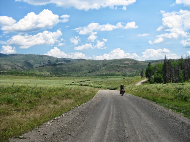
At some point today, we entered Colorado. When you're biking on forest and unimproved county roads, you don't always know where the delineation is. Or, for that matter, if you're on the correct road! (On that note, Wyoming was, for the most part, the best for directional signage on this route, especially the forest lands.)
With a nice clear day and, best of all, no wind, we continued on from our campsite at Battle Creek and followed what we thought was the road that the gray line on the ACA map represented which would bring us back to the route.
We had only made it a couple miles when we came upon the forest's latrine. I mean there was poop of different kinds all over the road and not a clear line was to be had for our tires. I managed to skirt most of it, but Alaine wasn't so lucky and her rear tire siezed up, encumbered by what stuck to her tire and then lodged up under her fender.
We had to remove the wheel just to clean things up to get rolling again. But the mystery remained, who made all the poop?
We rode on, then... aha! That's whose poop!
https://m.youtube.com/watch?v=z6xIV0Dg9oQ
Mystery solved, we continued on down the forest road seeing some amazing landscape, old cabins, soaring hawks and vistas to peaks across the valley which more or less confirmed we were on the right route.
But then we came upon the "Private Property, No Public Access, No Turn-Around" sign. We don't want to trespass, but neither do we want to go back the nine miles when we can see the road were looking for a mile from where we're standing. Alaine says, "What're they gonna do? Shoot us? And I'm thinking, yes. But Alaine reasons that, "We can be charming like Butch Casidy and the Sundance Kid if it comes to that." Or just be genuinely contrite, "we're lost, were sorry, please let us pass."

Continuing on, we came upon a structure tucked in the trees. We hallooed, but no response. Further on we went through a chained (but not padlocked) gate, then another and another, slowly downhill through lush and stunning pasture, riding along the ranch roads past grazing cattle. One ranchhand (we assumed) drove by on an ATV but didn't express concern over us and all our kits cycling through on the property. When we got to the ranch houses, Alaine walked up, yoohood, and instead of the imagined shotgun wielding old farmer a young woman came out and first thing asked, "Do you need water?" So welcoming, for all our concern about trespassing. She was not the owner, but said it was fine, and she'd let the owners know of our passage as well as our concern that we didn't abide by the sign. All was okay. Not so bad after all.

At the end of the ranch drive, we crossed the Little Snake River and returned to the official route, gravel road, which then traversed the ginormous property of Three Forks Ranch. It's not so much a working ranch as a hunting and fishing ranch for the very exclusive and even touts it's own private ski hill.
On tot the Routte National Forest and climbing, climbing (30 miles of it, steady) until the little outpost of Columbine, where we had some cold rootbeer before the 3 mile descent to Steamboat Lake, where we'd hoped to pitch a tent.
Campground full. Packed. RVs and tents and weekend campers everywhere, not many trees and no inviting lake access, and "no camping permits available." Discouraged, but not, in truth, really wanting to stay with the crowd and conditions, we decided, yep, again, to "push on." Filled all or water bottles in case... we didn't know where we'd end up, but... decided, Let's see if we can find camping along the way, or maybe even go all the way to Steamboat Springs.
We rolled along, toying at, below and above (meaning climbing) at 8000 feet for about 19 miles until crossing the Elk River and reaching the corner Clark Store. There, super fun-loving and helpful workers (owners?), internet to check on options, cold OJ with our warmed from the day's sun tuna, cheese and spinach wraps. A busy, happy, happening place with a great selection of about anything a traveler could need. And then the winds picked up, skies got dark. And though a nice guy recommended a camping area not too far off our route (which is not on the ACA map...) we opted to look for a room in Steamboat. Most places booked, but the Clark Store ladies were gracious about us using their phone to call around, and we got a room.
On the way, rain started, so garbed up in rain gear and get to Steamboat. A fast ride with Paul pulling, traffic being mostly courteous to give us room, especially in the stretches that started with that ominous signage: "Bicycles on Road" (meaning, no shoulder). Fast, through rolling farm country, fields of hay mid or post harvest, horses, a really beautiful stretch between Clark and Steamboat... and the rain let up
and then Alaine's sudden yelling snapped Paul from his focused pull, "Turn right, Paul! Turn right! Turn right, NOW!"
Butcherknife Brewery (Alaine had stared at the place for several seconds trying to figure why a knife sharpening shop would seem so hip looking, so it was within a few yards when she hollered to turn) had only been open for six weeks but thier Amputator IPA tasted like they were old professionals.
We had a great talk with Big Rob who was working the bar but also works for Big Agnes, based in Steamboat, and shared stories.
Then it was on to our motel to park our bikes (up the stairs!), get some food, then showers (yes, showers after, since it was after 8 when we went to eat), and konked out.
Day 30, Saturday, July 26, Battle Creek "campground" (WY) to Steamboat Springs, CO
66 miles (was supposed to have been 33), 7:36 ride time (though overall an 11-12 hour day with stops, 8.6 avg speed (lots of hill climbing!)
We're going to go vacation here next year!