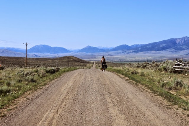
This part of the wide open Lewis and Clark Trail could be considered barren, but we found the openness exhilarating.

After we zigzagged through the flattest farm/ranch country, there were some patches of gnats or something or another on the highway that kept batting at my face. I almost considered pulling out the headnet! But like most everything...it passed. We saw some domestic ... perhaps reindeer? animals that had huge antlers, but they were far away and penned up and darn it, they didn't respond to my whistles or calls like some of the cattle along the way. There was also a mostly young female road crew out spraying weeds, specifically some uforbia type plant on the side of the road; once zapped they were a bright artificial green. Odd in the otherwise muted territory. Puffs of dust flew up and lingered as these young women passed on their ATVs--ATVs rule in Montana!!--the girls were all smiley and helmeted.
The roads were considerably remote with really no shade to be had; quite a change from a week ago in the Lolo and Helena National Forests.
Our planned destination for the day's camp was Morrison Lake, some 2 miles off route. But when we got to the turn, 40 miles into the day, it was still so early, especially at the pace we were going. So we decided to push to another spot on the route, some 16 miles further, that Paul had noted allowed camping and was near a creek so we could filter water. (I hope we didn't miss out on a fabulous lakeside camp--we'll never know!)
Our planned destination for the day's camp was Morrison Lake, some 2 miles off route. But when we got to the turn, 40 miles into the day, it was still so early, especially at the pace we were going. So we decided to push to another spot on the route, some 16 miles further, that Paul had noted allowed camping and was near a creek so we could filter water. (I hope we didn't miss out on a fabulous lakeside camp--we'll never know!)
We kept waiting to for lunch, hoping for a little shade, and we finally found some at a corner of a ranch driveway. Thank goodness for no "no trespassing" signs and premade Trail Butter (thanks, G & S!) dried cranberry tortillas!

Such incredible landscapes and geology shifts today, from open plains to high canyons; it felt almost a mix between Utah and Eastern Washington. Hot. Dry. Thirsty. But we were okay; though I found myself hoping that the couple of drivers to stop and say hello would offer us something to drink. We ended up grateful for a somewhat stillish creek crossing that was accessible to filter some water. So what if it was maybe on the cowish side.

We finally got to the Big Sheep Creek area where we immediately perched our bikes and headed in to cool off. Paul even did his submersion thing. We seriously considered camping there, as the water was so nice and the canyon feel was so inviting, but it was still just 2 o'clock 3 o'clock (?) and yes 66 miles into the day, but with the good trail/road and favorable breeze conditions, plus the fact that the possible camping was pretty close to the road, we instead filtered a bunch more water and – sure, let's go on another 5 miles to a BLM camp area shown on the map. There we encountered quite the disappointment--after now 71 miles. There was no great flowing water, it was rather barren, the sites were not very nice, and we were just not very happy. So what's another 11 miles? Let's just go all the way to Lima! (and this way maybe we would able to plan to camp the following day at the reservoir that Paul had had his eye on but hadn't thought our daily mileage/stopping plan would allow).
The last stretch on gravel was still good, and it wasn't until turning onto the frontage road, heading south, that we faced our first headwind of the long day. It often seems the last miles (in this case 7) of any day are always the worst!
But we made it to town-- 82 miles all told-- grateful for showers and some cold drinks and a good Montanan grilled steak and baked potato dinner, and a little time to spare to catch up on things. Paul's niece Haliey had her baby today.
"What's [82] miles of good road. Yes, I call that an easy distance."
Day 14, Thursday, July 10, Bannack State Park to Lima, MT.
82 miles, 10.4mph avg., 7:48 ride time

What their sign says:
William Clark and other members of the Core of Discovery passed through this area on July 8, 1806, as they return from the coast. They were anxious to get back to Fortune Camp, where they had cached supplies and canoes the year before. After almost 4 months of travel, they were running low on supplies and we're looking forward to corn, flour, pork, salt and especially the tobacco in the cache. Most of the men of the Expedition chewed tobacco. Clark consider the lack of tobacco "one of these severest privations which we had encountered."
What our sign would say:
The Borgias Haskins Expedition passed through this area on July 10, 2014, as they returned from the coast. After the United States Postal Service lost their first resupply package, the pair was anxious to get to any camp where they might discover cached supplies from which they might be able to appropriate. After only two weeks of travel, they were running low on supplies and had been looking forward to Mountain House Lasagna, Ola Loa vitamin/electrolyte powder, other unmentionable necessities, and Starbucks Via instant coffee. While Haskins drank IPAs and Borgias drank wine, they both drank Via coffee, and both agreed that the lack of Via coffee was "one of these severest privations which we had encountered."
No comments:
Post a Comment